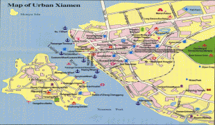
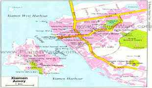
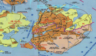
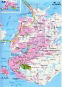
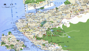
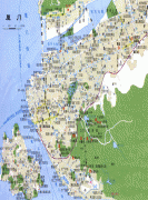
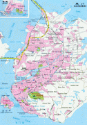
Xiamen
Xiamen Island possessed a major international seaport. The port of Xiamen is a well-developed first-class trunk line port in the Asia-Pacific region. It is ranked the 8th-largest container port in China and ranks 17th in the world. It is the 4th port in China with the capacity to handle 6th-generation large container vessels. On 31 August 2010, Xiamen Port incorporated the neighboring port of Zhangzhou to form the largest port of China's Southeast. Ever since the 12th century, Xiamen was also an important origin for many migrants to Singapore, Malaysia, Indonesia and the Philippines. The overseas Chinese used to support Xiamen's educational and cultural institutions. Xiamen is classified as a Large-Port Metropolis.
Xiamen is one of the top 70 cities in the world by scientific research as tracked by the Nature Index. The city is home to several major universities, including Xiamen, one of China's most prestigious universities as a member of the Project 985, Huaqiao, Jimei, Xiamen University of Technology and Xiamen Medical College.
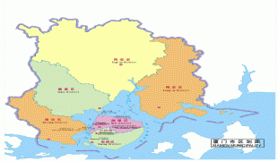
Xiamen had always been known as Tong'an County since antiquity until Republic of China Era of the 20th century, followed by administrative zoning restructures and naming changes.
Tong'an County first appeared in Han dynasty records. Xiamen Island was described as Jiahe Islet of Tong'an County during the Song dynasty (960–1279). It received its present name from the Xiamen Defense Castle erected on the island by Zhou Dexing in 1387 during the Ming dynasty to meet the needs of coastal defense. The name was formerly written using,, and then changed into or "Gate of China".
After the fall of the Ming dynasty, Zheng Chenggong, or Koxinga, a Ming loyalist and general, occupied Xiamen island as an anti-Qing base. In 1650, the seventh year of Emperor Shunzhi of the Qing dynasty, Zheng set a military base in Xiamen island and changed its name into, meaning "Remembering the Ming".
When its port prospered under the Qing, especially during the reign of Emperor Kangxi, the island's name was changed to again.
The island's name of 思明 was in return restored after the Xinhai Revolution that inaugurated the republic in 1912.
The island's name of 廈門 was restored in 1933, along with Xiamen being administratively planned as a city, the first of its kind in Fujian province. 思明 continues to be used as the name of one of its districts.
Xiamen is the atonal pinyin romanization of the characters' pronunciation in Mandarin. It has also been romanized as Hiamen. The older English name "Amoy" was based on the same name's pronunciation in the Zhangzhou dialect of Hokkien, Ēe-mûi.
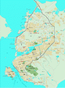
Map - Xiamen
Map


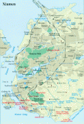


Country - China
 |
 |
| Flag of China | |
Modern Chinese trace their origins to a cradle of civilization in the fertile basin of the Yellow River in the North China Plain. The semi-legendary Xia dynasty in the 21st century BCE and the well-attested Shang and Zhou dynasties developed a bureaucratic political system to serve hereditary monarchies, or dynasties. Chinese writing, Chinese classic literature, and the Hundred Schools of Thought emerged during this period and influenced China and its neighbors for centuries to come. In the third century BCE, Qin's wars of unification created the first Chinese empire, the short-lived Qin dynasty. The Qin was followed by the more stable Han dynasty (206 BCE–220 CE), which established a model for nearly two millennia in which the Chinese empire was one of the world's foremost economic powers. The empire expanded, fractured, and reunified; was conquered and reestablished; absorbed foreign religions and ideas; and made world-leading scientific advances, such as the Four Great Inventions: gunpowder, paper, the compass, and printing. After centuries of disunity following the fall of the Han, the Sui (581–618) and Tang (618–907) dynasties reunified the empire. The multi-ethnic Tang welcomed foreign trade and culture that came over the Silk Road and adapted Buddhism to Chinese needs. The early modern Song dynasty (960–1279) became increasingly urban and commercial. The civilian scholar-officials or literati used the examination system and the doctrines of Neo-Confucianism to replace the military aristocrats of earlier dynasties. The Mongol invasion established the Yuan dynasty in 1279, but the Ming dynasty (1368–1644) re-established Han Chinese control. The Manchu-led Qing dynasty nearly doubled the empire's territory and established a multi-ethnic state that was the basis of the modern Chinese nation, but suffered heavy losses to foreign imperialism in the 19th century.
Currency / Language
| ISO | Currency | Symbol | Significant figures |
|---|---|---|---|
| CNY | Renminbi | ¥ or 元 | 2 |
| ISO | Language |
|---|---|
| ZH | Chinese language |
| UG | Uighur language |
| ZA | Zhuang language |